
Services We Offer
AGRICULTURAL STEWARDSHIP
ENVIRONMENTAL ASSESSMENT & REMEDIATION
Our Environmental Assessment and Remediation team has the knowledge and experience to bring world-class solutions to clients facing the challenges of environmental assessment, cleanup of contaminated properties, and Brownfield redevelopment.
WATER QUALITY
OUR WATER QUALITY CAPABILITIES STORMWATER ASSESSMENT & PERMITTING WATERSHED PLANNING WATER QUALITY & FLOW MONITORING ILLICIT DISCHARGE DETECTION & ELIMINATION (IDDE) HYDROLOGY AND WATER QUALITY MODELING COMMUNITY & COMMERCIAL WASTEWATER SOLUTIONS STORMWATER RETROFIT DESIGN TMDL IMPLEMENTATION SUPPORT ECOSYSTEM RESTORATION.
Geo location and mapping
Geo-location depends on coordinates to precisely identify particular points on the Earth’s surface. These coordinates are established through Global Navigation Satellite Systems (GNSS) like GPS (Global Positioning System). Our role involves creating and managing spatial databases to support the creation of urban, regional, natural resource, business, and utility network databases, both for prototyping and large-scale production. In addition to GIS database development, AGS provides various other geospatial and mapping services.
Topographical Surveying
Topographic surveying plays a crucial role in Tanzania, heavily depending on precise surveying and mapping methodologies. It involves delivering precise measurements and mapping of locations essential for engineering and construction endeavors. This includes aiding in the planning and arrangement of various infrastructure projects like roads, bridges, pipelines, and buildings. Additionally, it involves setting up reference points and markers at construction sites to ensure accurate placement of structures and utilities. Collaborating with architects, consulting engineers, local authorities, and government entities is integral to successfully executing major infrastructure and construction ventures.

Cadastral Surveying
Cadastral surveying in Tanzania commonly involves acquiring legal ownership of land or carrying out land-related transactions within the nation. Tanzania has precise laws and guidelines governing land ownership and management. Our surveying and mapping department consists of skilled professionals who are registered surveyors under the ‘THE LAND SURVEY ACT Chap 277’ and are affiliated with the Tanzania National Council of Professional Surveyors.
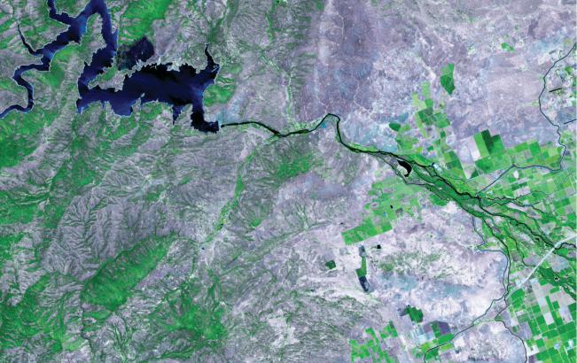
High Resolution Satellite & Drone/UAV
AGS offers high-resolution satellite and drone/UAV imaging services for various industries. Their advanced technologies provide detailed visual data, revolutionizing decision-making processes. With satellite images, they enable precise land cover mapping, environmental monitoring, and infrastructure planning. Their drone/UAV imaging services offer site surveys, precision agriculture solutions, and real estate assessments. By leveraging these services, businesses can make informed decisions, optimize processes, and gain valuable insights for success.

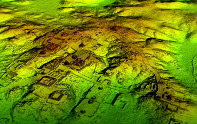
Remote Sensing including LiDAR Services
Remote sensing technologies like LiDAR services are transforming the observation and analysis of the Earth’s surface. Utilizing satellites, aircraft, drones, or ground-based sensors, they collect data without direct physical contact. These services offer extensive coverage, detailed imagery, and accurate 3D mapping, benefiting various fields including precision agriculture, environmental monitoring, disaster management, and infrastructure planning. They improve crop management, facilitate effective disaster response, and refine infrastructure design processes.
Some Other Popular Services We Provide
Spatial & Land use Planning Services
Mobile & Web Mapping Applications
Navigation and Geo-Location Analytics
Map Design and Production Services
Geospatial Intelligence Solutions
Real time GPS Asset Tracking Service
Hydrographic/bathymetric solution
2D Modelling
3D Modelling
Assets managements