PROJECT 2
SUMMARY
The sample project titled “Buea municipality drainage system”, saw the employment of Objective, Methodology and Results for the implementation of the project. To begin with, the objective was to identify and map out the major drainage system of the entire municipality, identify the source of the running water outlet and the final end point of the running water. Alongside this objective, some other findings were brought in; such is the case of the state of the drainage system, the identification of existing bridges and their state along the drainage system and lastly identification and mapping of a buffer zone within the drainage system in relation to housing construction along the said drainage system. With regards to the methodology used in this project; two phases were employed, that is the Data collection phase and the Data analysis face. Tools used within the methodology include; Garmin GPS, Satellite Image, Arcgis and Envi software respectively. Result obtained was a production of three cartographic maps which had to do with the Drainage system of the Buea Municipality.
METHODOLOGY
The project “Buea municipality drainage system” had two phases of methodology; that is Data collection and Data Analysis.
Data collection
This methodology employed the use of a Satellite Image (2021) and a Garmin GPS. The GPS was use in the tracking of the drainage within the municipality and collections of some major points such as bridges, localities, road junctions, water catchment, hospitals, schools and telecommunication pools.
The Satellite image was used to carry out two key activities, being; the confirmation of the coordinates collected from the field (Ground Truthing) and also for the identification of existing buildings within the buffer zone of the drainage system.
Date Analysis
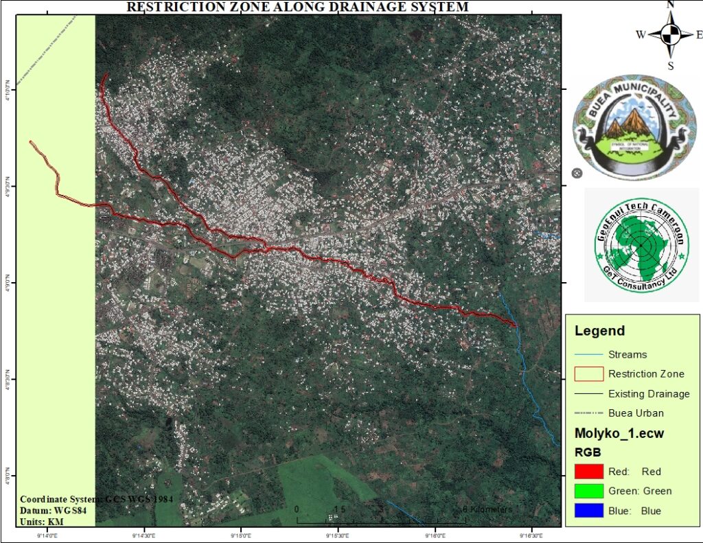
This phase of the project employes the use of geospatial software analysis such as Arcgis and Envi. Arcgis software help in the vectorization of the drainage system and also in the identification of the bridges along the drainage system. Again, this software was used in the identification of a buffer zone of 6 meters away from the drainage system. A high-resolution satellite image was used to identify buildings which fall within the buffer zone along the drainage system. Finally, ArcGIS was used in assembling of all the different data and production of the different maps.
FINDINGS
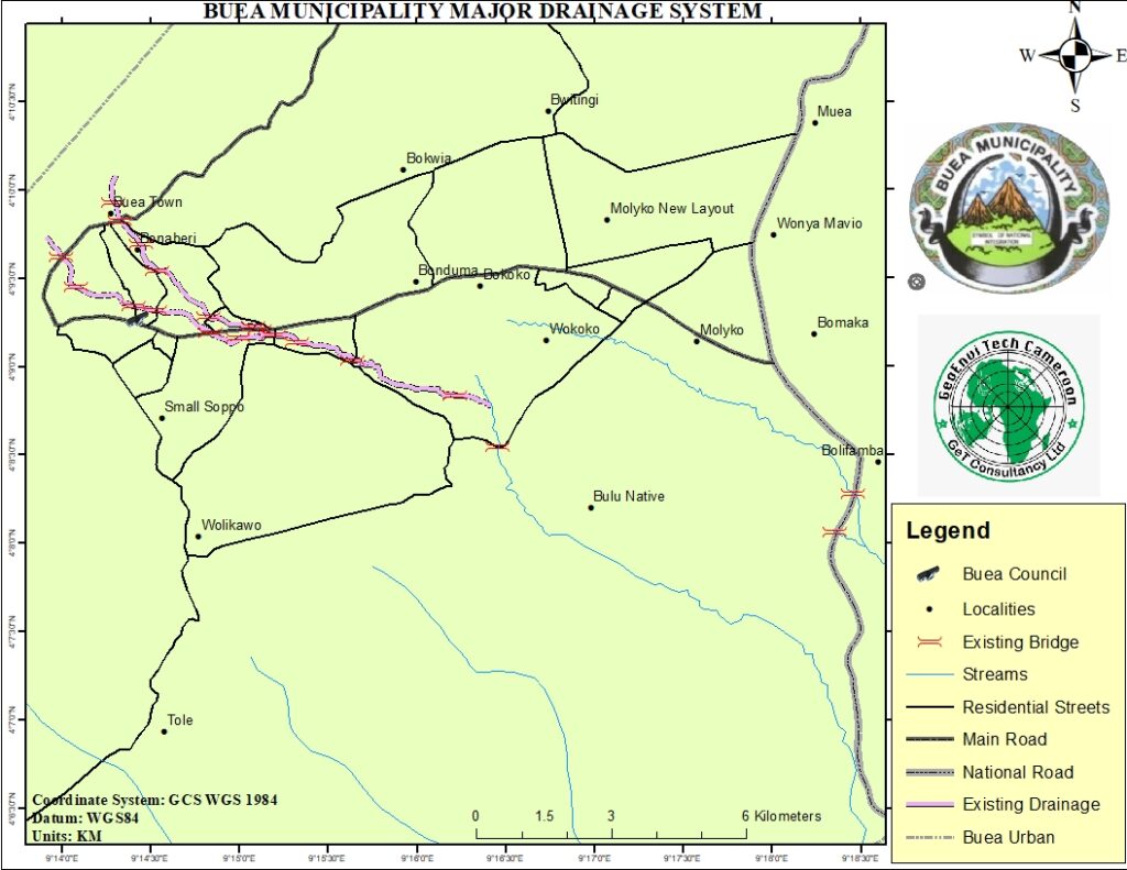
Drainage system
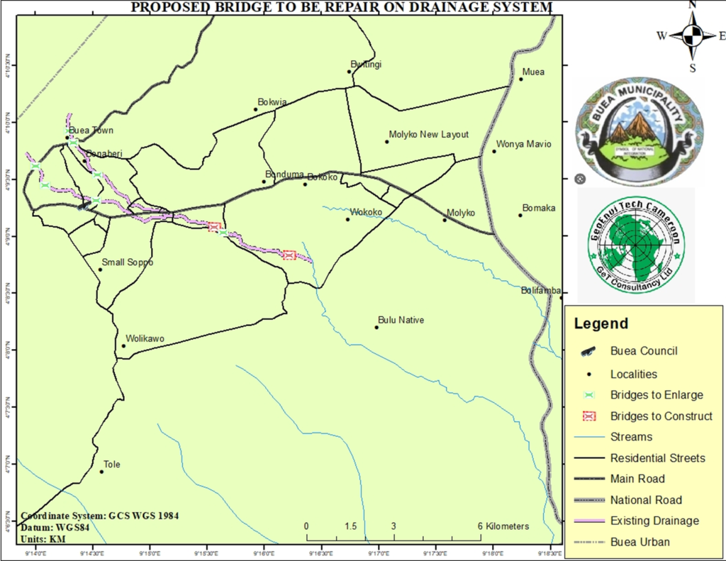
Two major drainage system can be identified within the municipality of Buea, this drainage system all take their rise from the mountain area. The first identified drainage system takes its rise from North West direction of the municipality and runs down towards the South of the municipality. It passes through localities such as Buea Town, Bonaberi, Street Seven, Street Two, Bakweri Town, Sandpit and joins a river flowing southward toward Bulu native. This drainage system covers a distance of about eight (08) km from the source point at Buea Town. In line with the housing distribution along the drainage system, a buffer zone of six (06) meters was created on the drainage system which identified building that were belt so close to the drainage system, therefore being an obstacle to the smooth flow of the running mountain water. A total of seventeen (17) bridges were identified along the drainage system and their state equally noted off. Of the seventeen (17) bridges identified along the drainage, seven (07) were identified as bridges in need for reconstruction and enlargement and two (02) bridges were identified for construction.
PROPOSAL
- Identification of the second main drainage system which flows eastward towards Muea.
- Proper construction of the identified and mapped drainage system, for proper town planning.
- Reconstruction and enlargement of existing bridges along the drainage system for the proper channeling of running water.
- Restructuring of the housing distribution along the existing drainage system.
ANNEX